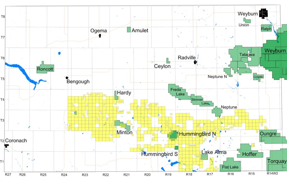
Regina – The map of exploratory licenses sold in the Oct. 5 land sale correlates to the Hummingbird-Roncott area. Not long after the sale, Crescent Point Energy Corp. declared they had acquired approximately 500 sections in the area for under $40 per acre, roughly equating the number of sections sold in the land sale under exploratory licenses.
Crescent Point president and CEO Scott Saxberg noted they were pursuing the Lodgepole formation. So what does this mean? On Nov. 10, Pipeline Newsspoke to Arden Marsh, senior petroleum research geologist; Dan Kohlruss, senior petroleum research geologist, and Melinda Yurkowski, assistant chief geologist; all with the Saskatchewan Geological Survey, Ministry of the Economy, to get the low-down on the Lodgepole Formation.
First of all, the Lodgepole Formation is referred to as the Souris Valley Beds in Saskatchewan. Marsh said, “The neighbouring jurisdictions have a lot more drilling and production within the interval that we call the Souris Valley Beds, and are able to sub-divide this stratigraphic unit more than we do, into different members.”
“In general, in Saskatchewan, it’s a fine-grained carbonate rock that is mostly dark grey in colour, with some lighter grey to buff colouration in some areas. It can vary from a lime-mudstone, to calcareous shales, and can also have some chert. There can also be a fair amount of fossiliferous and organic material, ooids (a small spheroidal calcium carbonate grain that has concentric layers around a nucleus) and generally coarser material, especially when you move further east of the Roncott-Hummingbird area. This variability in the rock also controls the porosity and permeability within the unit,” Marsh said.
Based on core analysis for Saskatchewan and Manitoba, to the edge of the basin, in general, for the Souris Valley Beds as a whole, the average porosity is approximately 11 per cent, but can be up to 41 per cent, in certain wells, especially where you get more fossiliferous materials.
The average permeability for Saskatchewan and Manitoba is 30 millidarcies, but that drops to 10 millidarcies for just Saskatchewan wells. As you move further west, into the Roncott-Hummingbird area that drops to an average of 1.6 millidarcies. However, there are also analyses from this area that can be up to 44 millidarcies.
“So generally it can be a somewhat tight rock, but it’s also going to be fairly brittle, as it’s a carbonate,” he said.
Some examples of core analysis in the area were from an extremely organic-rich zone within the Souris Valley Beds. “There can be an average of 69 per cent oil within the pore volume,” Marsh said. “That means 69 per cent of the porosity, through that zone is full of oil, and 11 per cent of the rock has porosity. So this means that you’re going to have a lot of oil in small pore spaces through this organic-rich interval.”
“There is also another well in the area, that’s analyzed through the similar interval, with 71 per cent average pore oil volume. These core analyses have up to 92 and 98 per cent maximum pore oil volume for those two wells, through this particular interval, which is extremely high. In this situation where you have relatively low porosity, but high oil volume, you need a large thickness for it to be useful.”
For thicknesses, he said within those two wells, one had pore oil volume greater than 53 per cent for 15 metres. The other well, where you had greater than 40 per cent pore oil volume was 51 metres thick. “You’re probably looking at a resource-type play”, he said.
That echoed Saxberg’s comments, referring to their acquisitions as a “large resource play.”
“To date, in the Souris Valley Beds, there is one producing well, but based on core analysis results, this area shows potential for additional production,” Marsh said.
Asked if such large thicknesses were common, Marsh responded, “We don’t have that many wells drilled into the Souris Valley Beds, in that area, so we have a very small data set to work from.”
“The Souris Valley Beds is made up of clinoforms that can vary greatly within one area. You can be dealing with one clinoform, and a few miles over, it can be something completely different.”
Clinoforms could be compared to shingles on a house, each having different properties. Rich zones may be restricted to one of those shingles.
“This is a really complex play and stratigraphic interval,” Marsh said.
Stratigraphically the Souris Valley Beds are directly above the Bakken Formation, with the Torquay Formation directly below the Bakken. The Torquay and Bakken formations fall in the late Devonian- early Carboniferous periods, while the Souris Valley Beds were deposited during the early part of the Carboniferous period, and the Mississippian epoch. In southeast Saskatchewan, above the Souris Valley Beds are, in order, the Tilston, Alida, Kisbey, Frobisher, Midale and Ratcliffe beds, all of which are oil bearing and have oil production.
“Basically, the Souris Valley, itself, is different than the Bakken (below it) and the rest of the Mississippian, above it,” Marsh said. “This is actually a deeper water-type deposit that would have formed on the slope, going down, towards the deeper basin. Water depths for a lot of these deposits, based on some the literature, would be 75 to 155 metres deep, when it was being deposited.”
According to sister publication CanOils, the Lodgepole (Souris Valley) in Manitoba has been the target for an increasing number of young wells in Manitoba. It’s also the formation that saw most of Manitoba’s production pre-1980, according to the Province of Manitoba.
The location of these organic rich deposits may be related to something underlying them in the stratigraphic column.
Salt dissolution
In the Hummingbird-Roncott area, understanding the timing of salt dissolution of the deeper Prairie Evaporite could be key.
Kohlruss said where salt dissolution occurred it’s going to be more of a conventional-type trap or play. “Will it contribute to the overall picture? Maybe. I don’t know if it’s the main target. The way these work is you need multiple events of salt dissolution over time. For example, during the time of, Duperow Formation deposition, if, during that time you had salt dissolution on a small scale, you’re creating an area like a bowl. That creates accommodation space in that bowl, and the Duperow will be thicker there. Fast forward to the Mississippian or Jurassic period, and more of that salt gets removed, but the morphology of the Duperow stays as that little bowl-shape.
“More salt gets removed, and all the above beds that were deposited, will now drape over that Duperow thick. And that creates an anticline.
“So will that affect the Souris Valley? Yes. Will it affect the Bakken? Yes. That play could have stacked reservoirs in that area, because you created something a little thicker, early on in the history. Now you have these kind of pop-up structures.”
Kohlruss noted it’s a good area to look for structural traps, if oil migrated through it. But it would be easy to miss small targets with individual wells or seismic.
“It’s a very complex area,” Yurkowski said.
Of the 47 Souris Valley wells drilled and fracked in Saskatchewan, 10 of the wells are in the Hummingbird-Roncott area, according to Marsh. “It’s a very heterogeneous carbonate with fairly low permeability, and it’s brittle.”
“I think, in the big picture, this will more likely be something that is a stratigraphic trap, where it’s a bigger area we’re dealing with, as opposed to focusing on the small structures,” Kohlruss said.
The Souris Valley rises as you go north, subcropping several townships north of Regina.
The top of the Souris Valley, not the organic-rich layer, is 2,291 meters below surface near the U.S. border.
The overall thickness of the entire Souris Valley Beds ranges from 59 metres thick in Township 8, to 184 metres thick at the U.S. border.
The oldest well in the region was spudded in 1920, drilled to a depth of 609 metres and completed in 1926. The first oil-producing well was drilling in 1952, drilled to the Interlake Formation. It’s still producing today from the Ratcliffe Beds. It’s in the Hoffer pool at 5-30-1-15-W2.
As noted previously, there’s currently only one well in the area that has produced from the Souris Valley. This area is mostly known for Red River, Winnipegosis, Birdbear Torquay, Bakken, and Ratcliffe production. As you move northeast, it’s a Midale-producing area.


